


Pusté Úľany, walking into the nature
Accommodation Pusté Úľany
List of tourist attractions Pusté Úľany

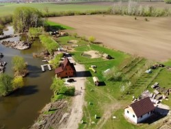
Nas Sen farm yard
Gazdovský dvor Náš Sen farm yard was created with the aim of building a place with regard to the natural needs of animals, where they will feel comfortable. The farm was made available to the public only thanks to the curious views of children and parents. The site is located in the village of Pusté Úľany in the district of Galanta, between Sládkovičovo and Veľký Grob, approximately 35 km from Bratislava. At Dvor Náš Sen, they keep domestic animals, such as were once kept in almost every country yard. Ducks, geese, horses, ponies, sheep, goats, cows, pigs, rabbits, chickens and pigeons...
Find Walking into the nature in the surrounding area of Pusté Úľany:
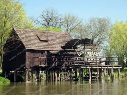
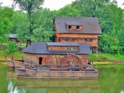
WATERMILL JELKA
The water mill in Jelka is located in a beautiful corner on the bank of the Little Danube. The restored mill, which originally belonged to Jozef Németh, is currently open to the public. A remarkable technical monument in southwestern Slovakia is accessible by a dirt road (1 km) from the road from the village towards Dunajská Streda. The oldest proof of the mill comes from 1894. The mill originally consisted of two ships built in the middle, connected by a massive mill wheel. The dominant part of...

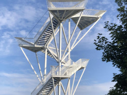
Lookout tower on Velká Homola

Chair-lift Železná Studnička
Chairlift from Studienka to Kamzik has an elevation of 186 meters and capacity of 342 persons peer hour. Its lower station is most easily reached by public transport bus line no. 43rd. It is the only attraction of its kind in a wide area of Bratislava. You can be transported not only to Kamzík - Koliba, but also back to Železná Studnička. It is possible to get in it on any station. The top station on Koliba can be reached by car. Also trolleybus 213 drives towards it. From the last bus...

JANKO KRÁĽ GARDEN
Sad Janka Kráľa (Janko Kráľ Orchard/Garden)is a park in Bratislava's Petržalka borough. It is located in the northern part of Petržalka, bordered by the Danube in the north, the Old Bridge access road in the east, a main road in the south and the Nový Most access road in the west. The park is one of the oldest municipal parks in Europe.[2] The statue of Janko Kráľ is situated in the park. The park was established in 1774-76 with the intention of creating a park for the public.
Lookout tower on Devínská Kobyla
The lookout tower on Devínská Kobyla is located at the intersection of hiking trails leading from Devínská Nova Ves, Devín and Dúbravka. The observation tower is located at the highest point of Devínská Kobyla at an altitude of 514 meters above sea level. It is also interesting because it is situated on the border of three states. From the observation tower you have a beautiful view of the near and far surroundings of Devínská Nová Ves, including three neighboring countries - Hungary,...
WATERMILL KOLÁROVO
Natural camp has already been predestined for its location for the most various activities. It is situated in the closeness of the town Kolárovo /ap. 500 meters ../ on the east border of „Rie island„. Natural camp lies on the foreland, which borders are formed by Small Danube and Váh from one side and by dried arm of Small Danube from other side. Since a half of the 15 th century belongs to the unthinkable part of the territory a Castle of peace its rummage /ground wall/ has been well...
Our tips
64.50 €
32.50 €

30.90 €

HEPEX Slovakia s.r.o.
All rights reserved.
Webdesign Pixa.sk
Change cookie settings