


Telgárt - tourist attractions
Accommodation Telgárt
List of tourist attractions Telgárt

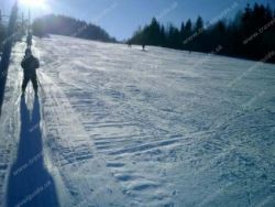
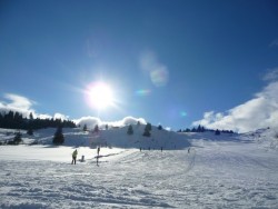
Ski resort Telgárt
Ski resort is located in the Horehronie region, in the village Telgárt, in the valley among the Low Tatras, Slovak Paradise and Slovak Ore Mountains, near the spring of the river Hron. The area lies directly at the foot of Kralova Hola. Telgárt Ski resort, which is at an altitude of 980 to 1300 meters, is suitable for a wide range of skiers, both downhill and cross-country skiing, and snowboarding. Beginners as well as experienced and advanced skiers come into their own. For them there is a ski trail with an elevation of 400 meters. Slopes are covered with snow. The resort features two...
Find Tourist attractions in the surrounding area of Telgárt:
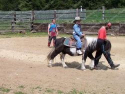
Ranch Pod Ostrou Skalou
Ranch pod Ostrou skalou is located in the village Dobšinská ľadová jaskyňa right next to the main road E-67 near the Slovak Paradise National Park. The ranch deals with the breeding of horses of various breeds, as well as the breeding of cows. For beginners and advanced, it offers horseback riding lessons, for more demanding customers, the ranch organizes one or more day trips in the saddle of horses with the possibility of camping in nature. Additional services include the possibility to participate...
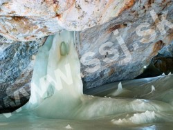
Dobšinská Ice Cave
The Dobšinská Ice Cave is situated in the Spiš-Gemer karst, in the national nature reserve Stratená, and by the character of glaciation belongs among the most important caves in the world. Ice fill occurs here in various forms and ice thickness reaches in some places 26 meters. The cave is located on the south-western edge of the Slovak Paradise National Park in the Spiš-Gemer karst. Cave entrance is on the northern slope of the Duča Hill at elevation of 969 m, 130 m above the bottom of...

Ski Vernár Studničky
Ski resort Vernár - Studničky is located about 20 km south of Poprad near the Slovak Paradise National Park. In its area you can ski at reasonable prices. The resort is suitable for beginners as well as advanced skiers. It offers organizing competitive rates for the school trips. There you will find ski rental. For those who are learning to ski, there are two lifts, and for better skiers there is a lift which takes you to the top of up to 980 metres above sea level. Transport capacity of the resort...

Snowmobiles Rejdová
If you look for adrenalin during the winter season, the snowmobiling in the Ski resort Rejdova provides you a great active holiday combined with relaxation. The ride on scooter will definitely be a great fun for more-members groups, families or corporate teams. You will enjoy an adrenaline ride on groomed trails in the beautiful natural surroundings of the Slovak Ore Mountains on the upper Gemer region near the southern edge of the Slovak Paradise. An unforgettable experience will be a snowmobile...

Ski area POHORELSKÁ MAŠA
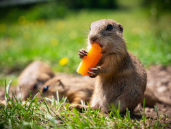
Ground squirrel area Muránska plain
This meadow full of friendly gophers is located in the middle of the Muránská plain, 2 km northeast of the village of Muráň, in the valley below the Murán castle. A huge ground squirrel colony lives here, which is the largest in Slovakia. The ground squirrel is one of the few places in the country where you can observe ground squirrels in the wild at close range. Ground squirrels from Muránská luka are very friendly and used to curious tourists. For a small treat, they are very happy to...
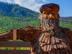
Obrovisko family park
You can find the Obrovisko family park near Sysľivosk on Muránská Planina. It is situated between the village of Muráň and the Predná Hora resort. In the area of the family park, you will find a fairytale-educational trail with wooden statues of giants, a MiniZoo, a large enclosure with alpacas and ponies, benches with beautiful views. On the fairy-tale and educational trail of Giants, you can get to know the story of the giants on Gemeri: where they are from, how they got here, what...
MURÁŇ CASTLE
Muráň Castle is a ruin of a medieval castle situated above the village of Muráň, in the Muránska planina National Park in Slovakia. The castle is noteworthy for its unusually high altitude of 935 m. It also figures in several romantic legends about its remarkable owners. Muráň Castle was built in the 13th century on a cliff overlooking a regional trade route. Its name is mentioned for the first time in 1271. The castle was damaged by fire in 1760. source: wikipedia.org
Palcmanská Maša Reservoir
Palcmanská Maša is the largest water reservoir in the Slovak Paradise National Park, created on the upper course of the Hnilec River, in a basin-like extension of the valley below the southern rocky slopes of the Geráv. The construction of the water reservoir was completed in 1956. The area is approximately 85 ha. On its shores there are accommodation, sports and recreational facilities. Fishing facilities are located directly on the lake. On the banks of the Palcmanská Maša reservoir, the village...

Cableway to Geravy
From August 7, 2023, the cableway to Geravy from the village of Dedinky was put into operation again after a long time. It is located in the southern part of the Slovak Paradise near the Palcmanská Maša water reservoir. The single-seat cable car with a track length of 1,988.7 meters has a transport capacity of 290 people per hour and an elevation of more than 200 meters. Photos: https://sobotnik.sk/2023/08/lanovka-geravy-dedinky/
SKI RESORT Liptovská Teplička

SKI Kubasok
Ski Centrum Kubašok Spišské Bystré is situated about 9 km south of Poprad at the foot of the northeastern part of the Low Tatras. Advantage of the area, north facing of ski slope allows keeping the snow during the whole winter season. Ski slopes are covered with artificial snow and groomed daily. With its difficulty and quality the resort is suitable for beginners but also experienced skiers meet their requirements. Further advantage of the ski area, its affordability will delight families...
Our tips
44.50 €
32.50 €

70.00 €

HEPEX Slovakia s.r.o.
All rights reserved.
Webdesign Pixa.sk
Change cookie settings