


Rožňava, walking into the nature
Accommodation Rožňava
List of tourist attractions Rožňava

Watermill Kovacova
We invite you to a tour of the water mill museum, which belonged to the Andrássy family from Krásná Hôrka with the original original equipment, where you will not only learn, but also see how flour was sometimes made. The water mill is located in the village of Kováčová near the town of Rožňava, in the Košice Region in eastern Slovakia.
Find Walking into the nature in the surrounding area of Rožňava:

Cableway to Geravy
From August 7, 2023, the cableway to Geravy from the village of Dedinky was put into operation again after a long time. It is located in the southern part of the Slovak Paradise near the Palcmanská Maša water reservoir. The single-seat cable car with a track length of 1,988.7 meters has a transport capacity of 290 people per hour and an elevation of more than 200 meters. Photos: https://sobotnik.sk/2023/08/lanovka-geravy-dedinky/

Sokolia dolina
Sokolia Valley, interesting also because it is the largest waterfall (75 meters high Veil Waterfall), the Slovak Paradise, is also called the wildest distress of this national park. The gorge is accessible by the yellow tourist trail from the Tomášovská Belá valley. While passing through the valley, tourists can also see the Side, Rock and Vyšný waterfall, where you can climb with ladders, bridges and belay chains. The hiking trail through Sokolia Valley will be a stunning experience and leave...
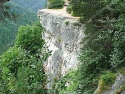
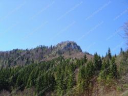
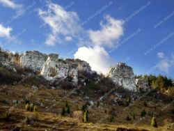
TOMÁŠOVSKÝ VÝHĽAD
The Tomášovský View is a terraced rocky outcrop located on the northern edge of the Slovak Paradise National Park. It offers a beautiful view of the valley of the White Stream, the Prielom Hornad, the Devil's Hall and in good weather also the High Tatras. Tomášovský's view is formed by a continuous rock, which, thanks to its width, achieves respectable dimensions. In the Slovak Paradise, Tomášovský View is one of the most visited parts of the National Park. It is a popular climbing...

Kláštorská roklina gorge
The Kláštorská gorge was created by a stream that springs near the Kláštorisko and flows into the Hornád river. It was opened for tourists in 1958, when a bridge was built over the Hornád gap, leading to the mouth of the gorge. From there, tourists can ascend to Kláštorisko, where the other end of the gorge is. During the hike through the gorge, visitors will be captivated by a number of waterfalls, unspoilt nature. The monastery gorge is part of the nature reserve Hornád Breakthrough.

Piecky gorge
Gorge Piecky is a national nature reserve with an area located in the northwestern part of the Slovak Paradise. The limestone gorge, which leads the tourist path in the direction upstream of the stream, flows into Hrabušická settlement Píla. At the beginning of the route there is Biela valley, where there is only a milder relief, but further followed by a more difficult terrain, which is formed by rocky cracks cascades and waterfalls. The more dangerous parts of the route in distress, which...
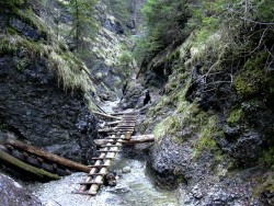
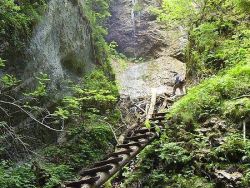
Suchá Belá Gorge
Suchá Belá is the most visited gorge in the Slovak Paradise, both for its accessibility and for its high concentration of waterfalls and exposed areas on a short stretch. Before the actual passage around the waterfalls the route leads through a wet river bed. Passage of the strait is allowed only upstream of the stream up the green tourist route. photos: www.novoveskahuta.sk
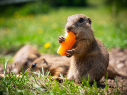
Ground squirrel area Muránska plain
This meadow full of friendly gophers is located in the middle of the Muránská plain, 2 km northeast of the village of Muráň, in the valley below the Murán castle. A huge ground squirrel colony lives here, which is the largest in Slovakia. The ground squirrel is one of the few places in the country where you can observe ground squirrels in the wild at close range. Ground squirrels from Muránská luka are very friendly and used to curious tourists. For a small treat, they are very happy to...
Dreveník – Travertine Hill near Spiš Castle
Dreveník is the largest travertine hill in Slovakia, located close to Spiš Castle. This natural monument is famous for its unique geological formations as well as its rare flora and fauna. Limestone structures created impressive cliffs, caves, and rock walls, making the area popular for hiking and climbing. Besides its natural beauty, Dreveník also has historical significance – traces of prehistoric settlement and valuable archaeological finds have been discovered here. From its plateau, visitors...
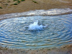
Sivá Brada (Mineral spring)
Sivá Brada is a travertine mound located near the town of Spišské Podhradie to the west. At its top, a mineral spring springs, creating a small lake with a diameter of 3 m, in the middle of which a continuously bubbling mineral water springs. Other mineral springs spring up in the area. Small cascades are formed from the draining water and thus troughs of small streams are created here. The travertine mound has been growing for about 10,000 years with such slow mineral deposition. In 1675, a baroque...
Our tips
64.50 €
32.50 €

80.00 €

HEPEX Slovakia s.r.o.
All rights reserved.
Webdesign Pixa.sk
Change cookie settings