


Oravská Poruba, walking into the nature
Accommodation Oravská Poruba
List of tourist attractions Oravská Poruba
Find Walking into the nature in the surrounding area of Oravská Poruba:
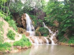
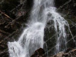
Lúčanský vodopád
photo: www.e-obce.sk
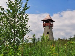
Lookout tower at Bobovec
The lookout tower on the Bobovec hill in Stará Bystrica was built in 2011 and opened on 27 August 2011. It offers you a beautiful view of Radôstka, Klubina, Nová and Stará Bystrica, as well as Malá Fatra. The lookout tower is brick, so visitors who are afraid of swaying wooden lookout towers do not have to worry. At the lookout tower there is a fireplace and a shelter with seating as well as information boards. The lookout tower and its surroundings are landscaped, upstairs there are brick...

Spicak Lookout Tower
The lookout tower on the Špicák hill near Strečno stands at an altitude of 620 m above sea level. It was built in the fall of 2017. The lookout tower with a height of over 8 meters is made entirely of wood. From the lookout tower you will have a panoramic view of the Žilina Basin, the ridge of the Little Fatra, part of the Kysucká Highlands and the Strážovské hills. The uniqueness of the lookout tower is that you can see 4 surrounding castles - Strečno, Old Castle, Budatín Castle and Lietavský...
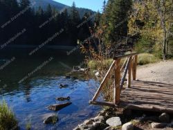
Vrbické Mountain Lake
Lake Verbicé (Slovak: Vrbické pleso) is one of the largest lakes in the Low Tatras, which has survived from the Ice Age. It is located at an altitude of 1113m above sea level in the western part of the Demänovská Dolina. The surface of the lake is 0.69 ha, the deepest point is 8 m deep, 115 m long and 62 m wide. Lake Moréna, formed by the retreat of glaciers from the northern slopes of the Chopok Mountains. The Otupnianka River flows from the lake, so the maintenance of a constant water level...
Hrádocké Arborétum
Hrádok Arboretum is located in the cadastral area of Liptovský Hrádok at an altitude of 650 m directly in the northern part of the city surrounded by housing estates. Despite its small size, the Hrádek Arboretum is currently unique in Europe. It is the highest situated arboretum in Central Europe and contains the fourth largest dendrological collections in Slovakia. The arboretum contains unique taxa from our and world dendroflora, which are listed in the Red Books of several states, and which...

Our tips
39.50 €
32.50 €

6.85 €

HEPEX Slovakia s.r.o.
All rights reserved.
Webdesign, SEO optimalizácia
by www.Pixa.sk