Tourist attractions in Slovakia

Horná Lehota, tourist attractions

Accommodation Horná Lehota
Show map
Horná Lehota Map

List of tourist attractions Horná Lehota
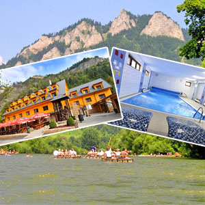
Ski Resort TÁLE Horná Lehota

Ski Resort TÁLE

Horná Lehota (area: Chopok south, region: Upper Hron River )

Well-liked ski resort with artificial snow conditions and maintained ski slopes lies in the heart of the Low Tatras, under Chopok hill (2024 metres over the sea level) and Dumbier hill (2043 metres over the sea level). Ski resort Tale features 6 lifts with a capacity of 4110 persons per hour, precisely maintained trails for demanding and less demanding skiers, snowboardcross track, slope reserved for beginners. The total length of artificial snow slopes is 2.77 km. Night skiing is on Fridays and Saturdays when there are 3 ski lifts and trails with a length of 1.5 km. Cross-country skiing...

Golf Resort GRAY BEAR Tále Horná Lehota

Golf Resort GRAY BEAR Tále

Horná Lehota (area: Chopok south, region: Upper Hron River )

The golf course GRAY BEAR is situated in the Tále recreational area, with well-established infrastructure, on the acreage of approx. 60 ha. The first 18 - hole championship golf course in Slovakia is located in the beautiful surroundings of Low Tatras National Park. The Tále golf club is the only domestic club on the Gray Bear golf playground that is the first master golf playground in Slovakia. The playground is 6 266 m long, par 71, holes with par 3 – 5, par 4 – 9, par 5 – 4, SSS is approx. 73,4. Gray Bear is the golf playground which will provide you unusual experience on every hole....
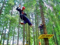
TARZANIA TÁLE Horná Lehota

TARZANIA TÁLE

Horná Lehota (area: Chopok south, region: Upper Hron River )

TARZANIA TÁLE is located in Tále, in the area of minigolf course. It is built of 23 obstacles at a height of approximately 5 to 7 m above the ground. It includes a route for the smallest climbers, so it is ideal place for families with children. The blue (shorter and lighter) route is 180 m long. The red (longer) route is 292 m long. The children's trail is 90 m long. When overcoming obstacles, each individual is secured with climbing equipment. Before entering the park, TARZANIA is given a briefing and training in the use of belay equipment.


Find Tourist attractions in the surrounding area of Horná Lehota:

Distance: 4.48kmSki Krpáčovo Dolná Lehota

Ski Krpáčovo

Dolná Lehota (area: Chopok south, region: Upper Hron River , District: Brezno)

Situated on the territory of the Low Tatras National Park, at an altitude of 768 m to 866 metres AMSL, you can find a ski resort Krpáčovo in the eponymous recreation area. You can reach it from Dolna Lehota or from the other side, from the resort Tále. Modest ski area belonging to the region Horehronie has 2 ski lifts, of which the longer lift has a length of 400 m and shorter lift has a length of 250 metres. The shorter slope with an elevation of 60 m is suitable for beginners or children....

Distance: 4.84kmBYSTRIANSKA CAVE Bystrá

BYSTRIANSKA CAVE

Bystrá (area: Chopok south, region: Upper Hron River , District: Brezno)

Situated on the southern side of the Low Tatras close to the tourism centres Tále and Mýto pod Ďumbierom. The cave have an abyss character with dominating flowstone curtains hanging on calcite crusts. Some parts of the Bystrianska Cave are used for speleotherapy since 1971. The cave is located in the ponor zone of the Bystrá-Valaská Karst in the Bystrá foothills of the Horehronské podolie, on the southern edge of the Bystrá village, nearby the recreational resort Tále and on the southern...

Distance: 6.81kmAJAX Farm Mýto pod Ďumbierom

AJAX Farm

Mýto pod Ďumbierom (area: Chopok south, region: Upper Hron River , District: Brezno)

Ajax Farm is ideal for adults who will find riding horses, as well as children who are waiting for their favorite ponies. We recommend the visit of Ajax Farm, which is located in a beautiful natural environment, especially for families with children who enjoy horseback riding. In addition to riding horses and ponies on our farm, you will see mini zoo animals such as hens, faucets, chickens, sheep and wickets, goats, turkeys and turkeys, buns, bunnies, cows, calves and several pairs of pigeons. You...

Distance: 7.40kmSki resort Mýto pod Ďumbierom Mýto pod Ďumbierom

Ski resort Mýto pod Ďumbierom

Mýto pod Ďumbierom (area: Chopok south, region: Upper Hron River , District: Brezno)

Situated in the southern part of the Low Tatras, 7 km from Podbrezova and 12 km from the town Brezno, the Ski resort Myto Pod Dumbierom meets the requirements of advanced skiers, but also does not forget those just starting out as well as children. Ski trails are located on slopes facing north. In addition to 4-chair lift, able to take 2,000 persons per hour to the top of a ski slope, the resort features further 3 lifts, and thus the total transport capacity of 3600 persons per hour. Snowmaking...

Distance: 8.84kmSkilift HRONEC - MAJER Hronec

Skilift HRONEC - MAJER

Hronec (area: Slovak Ore Mountains, region: Upper Hron River , District: Brezno)

The HRONEC - MAJER ski lift is located near the village of Hronec in the Banská Bystrica region, 5 km from the town of Brezno. The artificially snowed slope with a length of 600m and an elevation gain of 80m is artificially snowed during the winter season and also offers the possibility of night skiing. Operating hours: 9.00 - 16.00 Evening skiing (Friday, Saturday): 18.00 - 21.00

Distance: 9.73kmHRONEC - HLOBIŠOV Ski Resort Hronec

HRONEC - HLOBIŠOV Ski Resort

Hronec (region: Upper Hron River , District: )

Ski lift Hronec - Hlobišov is located near the village Hronec nearby cities Brezno and Podbrezová. The total length of the slope, located in the mountains Veporské is 2.4km and its elevation is about 200 meters.

Distance: 9.98kmHorehronie Express Brezno

Horehronie Express

Brezno (area: Chopok south, region: Upper Hron River , District: Brezno)

Distance: 10.85kmHorehronské Museum Brezno Brezno

Horehronské Museum Brezno

Brezno (area: Chopok south, region: Upper Hron River , District: Brezno)

Distance: 15.92kmDead Bats Cave Jarabá

Dead Bats Cave

Jarabá (area: Čertovica, region: Upper Hron River , District: )

Distance: 16.24kmSki resort Čierny Balog Čierny Balog

Ski resort Čierny Balog

Čierny Balog (area: Slovak Ore Mountains, region: Upper Hron River , District: Brezno)

Ski resort Cierny Balog is located in the popular tourist centre, 9 km from Brezno. A lot of good skiing can be enjoyed on 6 slopes that are suitable for families, advanced skier, beginner, snowboarder and cross country skiing. The ski slope is very well usable for fans of extreme sports such as paragliding. In the resort there are 2 ski lifts with a length of 1100 m and children's ski lift (250 m). Transport capacity of the lifts is 2500 persons per hour. The slopes are artificially snowed...

Distance: 18.71kmForest Open Air Museum Vydrovo Čierny Balog

Forest Open Air Museum Vydrovo

Čierny Balog (area: Slovak Ore Mountains, region: Upper Hron River , District: Brezno)

Forestry museum is situated in Vydrovská valley in the region of Horehronie, about 1 km from the Čierny Balog. Here, in the beautiful forest surrounding of Veporské Hills, you can see various exhibits that got you acquainted with the forestry - with its past and present. 3 km long route, called the Walk of Forestry Time currently consists of 75 stops. They'll share the importance of forests in our lives. You will learn what all is necessary for the conservation and protection of forests. The...

Distance: 18.74kmČierny Hron Railway Čierny Balog

Čierny Hron Railway

Čierny Balog (area: Slovak Ore Mountains, region: Upper Hron River , District: Brezno)

Ciernohronska (Black Hron) railway is a narrow-gauge forest railway in the Slovak Ore Mountains, which drives on the route Chvatimech - Hronec - Čierny Balog - Vydrovo. Railway was originally built to improve transport of harvested timber, since the capacity and quality of transport of wood in the traditional way - rafting failed to meet the needs of the growing industry of the country. It was necessary to ensure the quality and smooth transport of timber throughout the year. The construction...

HINT
Distance: 19.84kmSKI JASNA Low Tatras Demänovská Dolina

SKI JASNA Low Tatras

Demänovská Dolina (area: Demanovska Valley and surroundings, region: Liptov, District: Liptovský Mikuláš)

The Jasná Low Tatras resort is ranked in the highest category of centres of tourism with international importance and among the Slovak centres of tourism it holds the first rank. It is situated in beautiful mountainous surroundings, on northern and southern slopes of Chopok, in the Low Tatras National Park. The Jasná Low Tatras ski resort is the largest resort with the best natural conditions for skiing in Slovakia. Those keen on snowboarding, ski-alpining, freeride and track skiing will surely...

Distance: 20.06kmVrbické Mountain Lake Demänovská Dolina

Vrbické Mountain Lake

Demänovská Dolina (area: Demanovska Valley and surroundings, region: Liptov, District: Liptovský Mikuláš)

Lake Verbicé (Slovak: Vrbické pleso) is one of the largest lakes in the Low Tatras, which has survived from the Ice Age. It is located at an altitude of 1113m above sea level in the western part of the Demänovská Dolina. The surface of the lake is 0.69 ha, the deepest point is 8 m deep, 115 m long and 62 m wide. Lake Moréna, formed by the retreat of glaciers from the northern slopes of the Chopok Mountains. The Otupnianka River flows from the lake, so the maintenance of a constant water level...

Distance: 20.49kmTarzania JASNA Demänovská Dolina

Tarzania JASNA

Demänovská Dolina (area: Demanovska Valley and surroundings, region: Liptov, District: Liptovský Mikuláš)

TARZANIA JASNA is located in the beautiful Liptov countryside in the recreational center Jasná in Demänovská Valley. It is built on trees and consists of two trails built with 34 platforms and 95 obstacles at a height of approximately 4 to 7 m above the ground. The blue (shorter and lighter) route measures 281 m. The red (longer) route is 396 m long. When overcoming obstacles, each individual is secured with climbing equipment. Before entering the park, TARZANIE is given a briefing and training...