


Tajov, walking into the nature
Accommodation Tajov
List of tourist attractions Tajov
Find Walking into the nature in the surrounding area of Tajov:

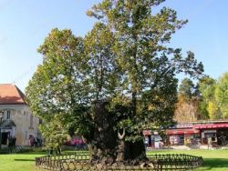
Arboretum KYSIHÝBEL
Forest Arboretum Kysihýbel near Banská Štiavnica was founded in the early twentieth century, on account of research on introduction and cultivation of exotic forest trees. Arboretum area is divided into four parts. It is located at an altitude of 530-563 meters, and its total area is 7.78 hectares. A t the beginning 282 trees of temperate zones of the northern hemisphere were planted in the arboretum. Currently, there are around 260 species of trees. The area of arboretum includes the International...
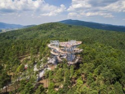
Lookout Tower Bojnice
The Lookout Tower in Bojnice is located in the mountains above the town of Bojnice and offers an unforgettable view of the surroundings. The unmistakable building with an elevation of about 30 meters has a steel structure and a wooden footbridge. Part of the lookout tower is also a slide, which children can lower from the top of the tower. From the tower you can see not only Bojnice castle but also the far side of the town Prievidza. Next to the lookout tower there was also a small village...

Forest Open Air Museum Vydrovo
Forestry museum is situated in Vydrovská valley in the region of Horehronie, about 1 km from the Čierny Balog. Here, in the beautiful forest surrounding of Veporské Hills, you can see various exhibits that got you acquainted with the forestry - with its past and present. 3 km long route, called the Walk of Forestry Time currently consists of 75 stops. They'll share the importance of forests in our lives. You will learn what all is necessary for the conservation and protection of forests. The...
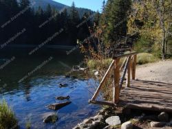
Vrbické Mountain Lake
Lake Verbicé (Slovak: Vrbické pleso) is one of the largest lakes in the Low Tatras, which has survived from the Ice Age. It is located at an altitude of 1113m above sea level in the western part of the Demänovská Dolina. The surface of the lake is 0.69 ha, the deepest point is 8 m deep, 115 m long and 62 m wide. Lake Moréna, formed by the retreat of glaciers from the northern slopes of the Chopok Mountains. The Otupnianka River flows from the lake, so the maintenance of a constant water level...
Our tips
37.50 €

32.50 €
28.50 €

HEPEX Slovakia s.r.o.
All rights reserved.
Webdesign, SEO optimalizácia
by www.Pixa.sk