


Poľný Kesov, national cultural monuments
Accommodation Poľný Kesov
List of tourist attractions Poľný Kesov
Find National cultural monuments in the surrounding area of Poľný Kesov:
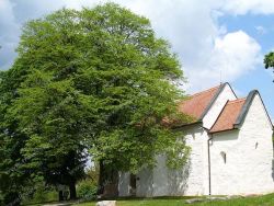
SAINT GEORGE'S SMALL CHURCH
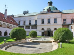
Topoľčianky Manor House and Castle
The village of Topoľčianky, which is located north of the western Slovak town of Zlaté Moravce at the foothill of the Tribeč Mountains, boasts an extensive English garden, which features a picturesque Classicist-style manor house that forms the southern wing of an old castle. The area originally featured a Gothic-style water castle and later a Renaissance fortress. At the outset of the 19th century, the then owner of the castle Count Ján Keglevich pulled down the southern Renaissance tract...
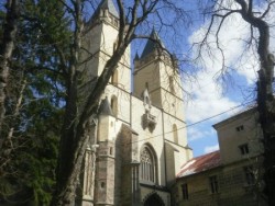
Benedictine Monastery Hronský Beňadik
Benedictine monastery in Hronský Beňadik consists of a set of fortified sacral buildings in the village Hronský Beňadik in the district of Žarnovica in Banská Bystrica region. The monastic complex its stunning visitors with contemporary monumentality is a unique combination of sacred buildings and fortification as well as the symbiosis of different building styles - Gothic, Renaissance and Baroque. The complex of buildings even today seems to be as a guardian of the crossroads. Benedictine...

Roman Lapidarium Komárno
The Exhibition "Roman Lapidarium" is installed in the southern bastion of the Komarno fortress. Opening hours: May - October: Tue-Sun 10.00 a.m. - 5 p.m.

The Townhall Komárno
The building is located at 1 Klapka Square. It is the most characteristic neo-classicist building. The original townhall was built as a one-storey building in 1718-19. It was reconstructed in 1725 but the earthquake in 1763 damaged it completely and it was in ruins. It was rebuilt in 1766. Its tower covered with copper was completed in 1767 and on top of it the symbol of the Habsburg Monarchy was placed: a huge two-headed eagle. Unfortunately, the great fire in 1848 damaged the building again...
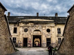
FORTRESS KOMÁRNO
The fortification system in Komárom is a unique military complex, its significance spreading over the borders of Hungary and Slovakia. In the 19th century it was the most powerful and the biggest construction of the Austro-Hungarian Monarchy. Its invincibility is commemorated by the statue of the “Stone Virgin“ decorating the Western Bastion of the New Fortress and the sign undrneath which says: NEC ARTE NEC MARTE – neither by trick nor force. These words characterise precisely the whole...
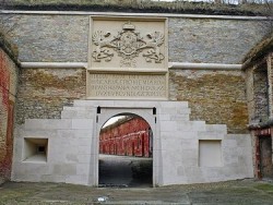
Ferdinand gate
National monument - Old Fort, which is the provisional list of World Heritage Site welcomes its guests newly renovated Ferdinandova gate. You can see there a memorial plaque on the facade with the coat of arms and the inscription Ferdinand I Roman Emperor. In 2011, the reconstruction of the entire entrance to the Old Fort was completed. The construction of the fortress was ordered in 1541 by the Roman-German Emperor Ferdinand I of Habsburg, therefore the gate was named after him. It was the first...
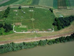
CELEMANTIA IŽA
Celemantia was a Roman castellum and settlement on the territory of the present-day municipality Iža, 4 km to the east of Komárno. It is the biggest known Roman castellum in present-day Slovakia. It was a part of the Roman Limes, the frontier-zone of the Empire.
Our tips
37.50 €

39.00 €
29.50 €

HEPEX Slovakia s.r.o.
All rights reserved.
Webdesign, SEO optimalizácia
by www.Pixa.sk